





This article as a PDF.
The following is not a futuristic scenario. It is not science fiction. It is a demonstration of the capabilities of GIS to model the results of an extremely unlikely, yet intellectually fascinating query: What would happen if the earth stopped spinning? ArcGIS was used to perform complex raster analysis and volumetric computations and generate maps that visualize these results.
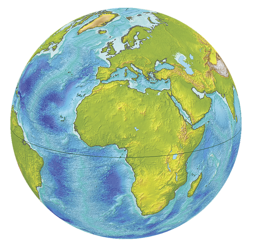 The world as we know it. The obvious demarcation of land and ocean is indicated by the contour of 0 elevation.
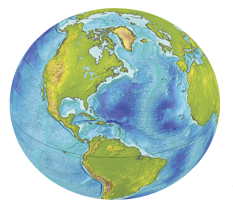 The longer, equatorial axis of Earth's ellipsoid is more than 21.4
km (or 1/3 of 1 percent) longer than the polar axis. The flattening of
the ellipsoid shown on this map was intentionally exaggerated.
The longer, equatorial axis of Earth's ellipsoid is more than 21.4
km (or 1/3 of 1 percent) longer than the polar axis. The flattening of
the ellipsoid shown on this map was intentionally exaggerated.The most significant feature on any map that depicts even a portion of the earth's ocean is the spatial extent of that water body. Typically, we do not pay much attention to the delineation of the sea because it seems so obvious and constant that we do not realize it is a foundation of geography and the basis for our perception of the physical world.
The line separating oceans from continents outlining the spatial extent of both land and water is the most fundamental contour. It is zero elevation because it signifies the sea level. Why is the sea level where we currently observe it? What controls the sea level? How stable are the forces that determine the sea level? This article does not refer to the climate change and the potential increase of the water level in the global ocean but rather to the geometry of the globe and the powerful geophysical energies that determine where oceans lie.
Sea level is—and has always been—in equilibrium with the planet's gravity, which pulls the water toward the earth's center of mass, and the outward centrifugal force, which results from the earth's rotation. After a few billion years of spinning, the earth has taken on the shape of an ellipsoid (which can be thought of as a flattened sphere). Consequently, the distance to the earth's center of mass is the longest around the equator and shortest beyond the polar circles. The current difference between the average sea level as observed along the equator and the distance to the earth's center of mass from the sea level at the poles is about 21.4 kilometers (km).
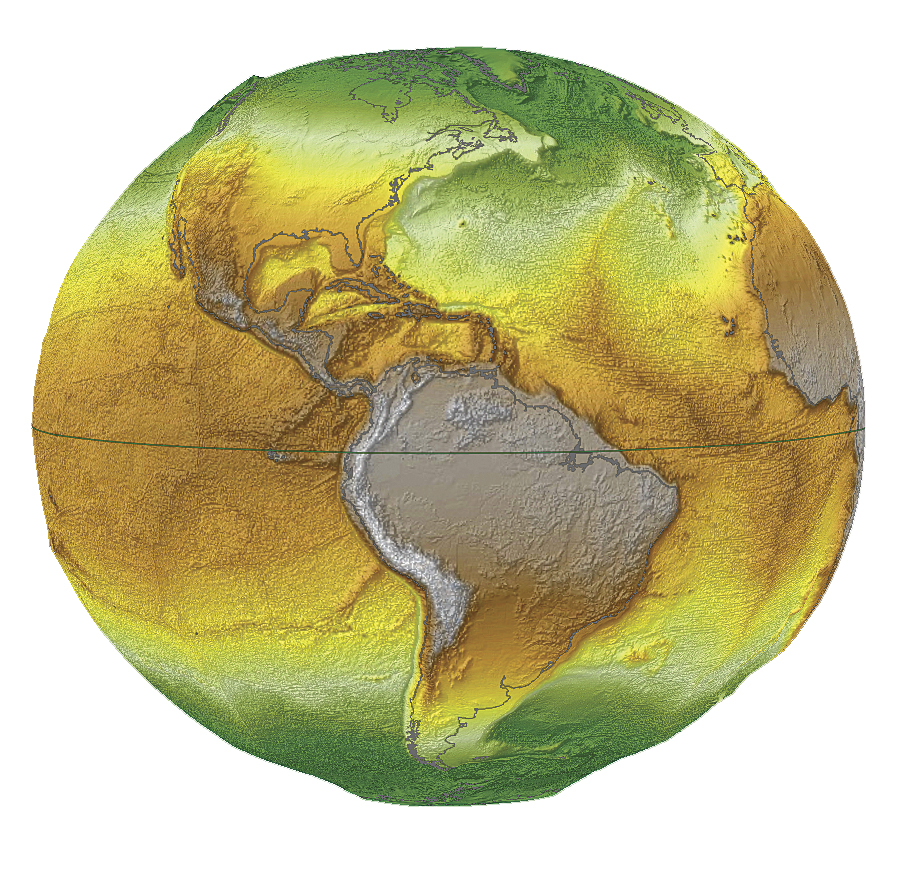 The gravity of the still earth is the strongest at the polar regions
(shown in green). It is intermediate in the middle latitudes and
weakest at the high altitudes of the Andes, close to the equator.
The gravity of the still earth is the strongest at the polar regions
(shown in green). It is intermediate in the middle latitudes and
weakest at the high altitudes of the Andes, close to the equator.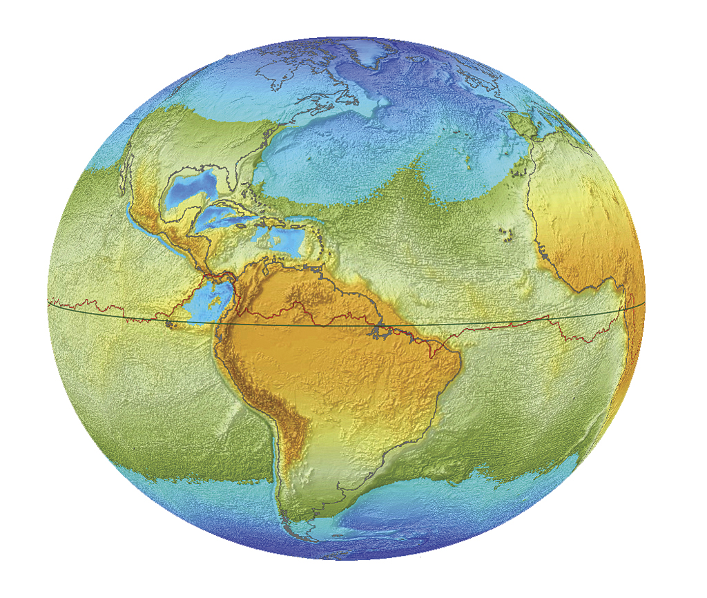
When global rotation stops, the massive
oceanic water migration would cease and sea level would be at different
locations, completely changing world geography.
What would happen if the earth's rotation slowed down and finally stopped spinning over a period of a few decades? ArcGIS lets us model the effects of this scenario, performing calculations and estimations and creating a series of maps showing the effects the absence of centrifugal force would have on sea level.
If earth ceased rotating about its axis but continued revolving around the sun and its axis of rotation maintained the same inclination, the length of a year would remain the same, but a day would last as long as a year. In this fictitious scenario, the sequential disappearance of centrifugal force would cause a catastrophic change in climate and disastrous geologic adjustments (expressed as devastating earthquakes) to the transforming equipotential gravitational state.
The lack of the centrifugal effect would result in the gravity of the earth being the only significant force controlling the extent of the oceans. Prominent celestial bodies such as the moon and sun would also play a role, but because of their distance from the earth, their impact on the extent of global oceans would be negligible.
If the earth's gravity alone was responsible for creating a new geography, the huge bulge of oceanic water—which is now about 8 km high at the equator—would migrate to where a stationary earth's gravity would be the strongest. This bulge is attributed to the centrifugal effect of earth's spinning with a linear speed of 1,667 km/hour at the equator. The existing equatorial water bulge also inflates the ellipsoidal shape of the globe itself.
 The extent of a hypothetical northern circumpolar ocean over the
territory of North America is shown. The orange color indicates areas
with elevation higher than 3,000 meters above the level of the northern
ocean. Red dots represent some of the biggest cities of the continent.
The extent of a hypothetical northern circumpolar ocean over the
territory of North America is shown. The orange color indicates areas
with elevation higher than 3,000 meters above the level of the northern
ocean. Red dots represent some of the biggest cities of the continent.The bulge defines the final shape of the globe by establishing the uniform sea level in gravitational equilibrium, which is used as the standard reference for describing the shape of the earth. It is the geometry of this very shape that geodesists were trying to calculate for more than a century. Their efforts were finalized by the acceptance of the ellipsoid referred to as World Geodetic System 1984 (WGS84) by the international community in Washington, D.C., in 1984. The ellipsoid WGS84 approximates the shape of the earth more accurately than many other ellipsoids that were previously proposed.
If the earth stood still, the oceans would gradually migrate toward the poles and cause land in the equatorial region to emerge. This would eventually result in a huge equatorial megacontinent and two large polar oceans. The line that delineates the areas that hydrologically contribute to one or the other ocean would follow the equator if the earth was a perfect ellipsoid. However, due to the significant relief of both the continents and the ocean floor, the hypothetical global divide between the areas that hydrologically contribute to one or another ocean deviates from the equator significantly. Analogous to the well-known U.S. Continental Divide, this would be the border separating two giant hemispherical watersheds of the new circumpolar oceans. Interestingly, the highest point on this global divide would not be the highest altitude on the entire globe. The highest elevation of the global divide in the Colombian Andes would be about 12,280 meters, whereas the altitudes of the famous equatorial volcanoes of Chimborazo (Ecuador) and Kilimanjaro (Tanzania) would be 13,615 and 12,786 meters, respectively. Both volcanoes happen not to be located on the global divide line. The lowest point on the new global dividing line, with an elevation of 2,760 meters, would be situated southwest of Kiribati Island in the western Pacific.
Due to the unique relief of the earth's surface at the beginning of the slowdown, the most significant changes to the outline of land versus water would occur at the high latitudes of the northern hemisphere where the swell ocean would quickly expand over the flat and vast territories of northern Siberia and northern Canada. At the same time, changes to the continental outlines at low latitudes would be barely perceptible because (with a few exceptions) equatorial waters are deep, and a decrease in water level by a few dozen meters would not cause large areas of land to emerge. Toward the end of the slowdown period, when the main geographic features of oceans and land would have already adjusted to the ellipsoidal shape of the globe and the new distribution of gravity, relatively small changes would occur. This can be attributed to the ellipsoidal shape of the globe, which overwhelms the effect of the diversity of the earth's geographic relief.
Today, all three world oceans are connected. This creates a global ocean with basically one sea level. As a consequence of rotational slowdown, the outline of the global ocean would continuously undergo dramatic changes. Equatorial waters would move toward polar areas, initially causing a significant reduction in depth while filling the polar basins that have much less capacity. As regions at high latitude in the northern hemisphere become submerged, the areal extent of the northern circumpolar ocean would rapidly expand, covering the vast lowlands of Siberia and northern portions of North America. The global ocean would remain one unit until the rotation of the earth decreased to the speed at which ocean separation would occur. The interaction between the inertia of huge water bodies and decreasing centrifugal force would be very complicated. As the consequence of steady slowdown of earth's rotation, the global ocean would be gradually separated into two oceans. Obviously, the last connection will be broken at the lowest point of the global divide line, located southwest of the Kiribati Islands. Since the current western Pacific Ocean is a plane, land would emerge quickly because there would be no chance that water would be exchanged between the two circumpolar oceans after the initial split. The area of final separation between the two oceans would be the simultaneous emerging and drying of territory extending for hundreds of kilometers.
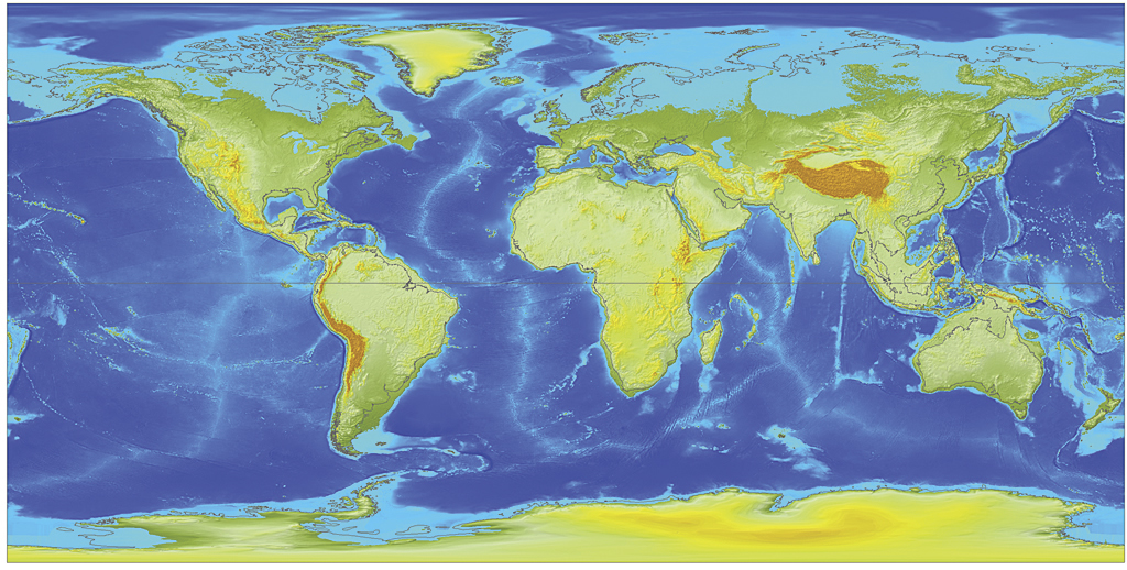 While gravity pulls more water toward the Arctic Ocean, the lowlands
of Siberia and northern Canada would become submerged. The
corresponding movement of water away from the equatorial region combined
with the shallow continental shelf waters southeast of Asia and north
of Australia will cause land to emerge.
While gravity pulls more water toward the Arctic Ocean, the lowlands
of Siberia and northern Canada would become submerged. The
corresponding movement of water away from the equatorial region combined
with the shallow continental shelf waters southeast of Asia and north
of Australia will cause land to emerge.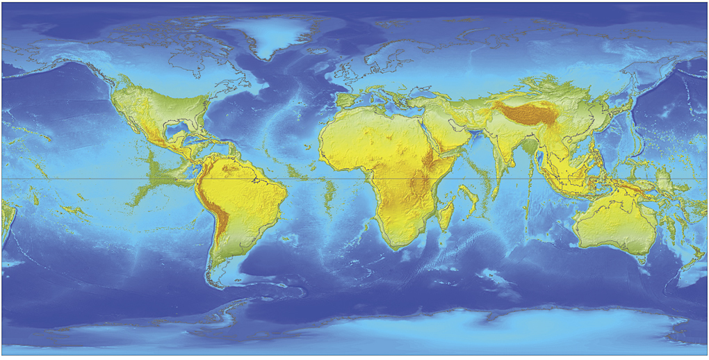 A deepening Arctic Ocean would lead to the further expansion of
water over the northern plains of Asia, Europe, and North America.
Greenland and Antarctica, despite their high elevations, would become
significantly smaller in size. New archipelagos emerge from the southern
seas. The Great American Lakes, the biggest freshwater reservoirs in
the world, dissolve into the ocean.
A deepening Arctic Ocean would lead to the further expansion of
water over the northern plains of Asia, Europe, and North America.
Greenland and Antarctica, despite their high elevations, would become
significantly smaller in size. New archipelagos emerge from the southern
seas. The Great American Lakes, the biggest freshwater reservoirs in
the world, dissolve into the ocean.The slowdown would continue after the separation of the two oceans and cause further migration of the ocean water toward the poles. Surprisingly (despite Antarctica's elevation), the southern polar basin has a larger capacity than the northern one. Given the fixed volume of water in both hemispheres, the more capacious basin of the southern pole would result in an overall lower sea level than the northern ocean. According to volumetric calculation performed with the ArcGIS 3D Analyst extension, the difference between the sea level of the two oceans should be 1,407 meters. However, the data accuracy does not warrant this level of precision, so the elevation difference between the sea level of the two oceans used was 1,400 meters.
The series of maps illustrating this article depict the intermittent stages during this migration of the earth's oceans and changes in land extents, topographic elevation, and bathymetric depth caused by the decreasing speed of the earth's rotation. These maps demonstrate the intermediate stages of transitional geography from a rotating to a stationary world. They show the effects of the gradual reduction of centrifugal force from its current level to none, leaving gravity as the only force controlling the ocean's extent.
The actual slowdown of the earth's rotation has been observed, measured, calculated, and theoretically explained. As newer methodologies are developed and more precise instruments are constructed, the exact rate of the slowdown may vary between some sources. Reflecting this very gradual slowing, atomic clocks must be adjusted to solar time by adding a leap second every so often. The first leap second was added in 1956.
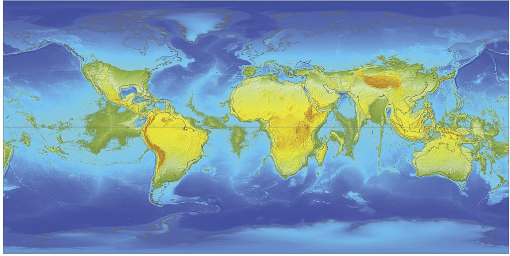 All Antarctica would be under water at this point. The north polar
waters and the water over the vast, recently submerged territories in
Siberia and Canada would be getting deeper. At the same time, equatorial
waters would be getting more shallow.
All Antarctica would be under water at this point. The north polar
waters and the water over the vast, recently submerged territories in
Siberia and Canada would be getting deeper. At the same time, equatorial
waters would be getting more shallow.  Large land areas near the equator continue growing and join with
each other. By now, nearly all of Canada, Europe, and Russia are covered
by a northern circumpolar ocean.
Large land areas near the equator continue growing and join with
each other. By now, nearly all of Canada, Europe, and Russia are covered
by a northern circumpolar ocean.Most scientists agree that the solar day (related to the speed of rotation) is continuously getting longer. This minimal increase of the day length is due mainly to the oceanic tidal friction. When the estimated rate of the slowdown was projected back to past geologic eons, it showed that the length of a day was several hours shorter than today.
Consequently, during the Devonian period (400 million years ago), the earth rotated about 40 more times during one revolution around the sun than it does now. Because the continents have drifted significantly since that time, it is difficult to make estimates of the land versus ocean outlines for that era. However, we can be certain that—with a faster spinning speed in the past—the equatorial bulge of oceanic water was much larger then than it is today. Similarly, the ellipsoidal flattening of the earth was also more significant.

This animation depicts the intermittent stages during this migration of the earth's oceans and changes in land extents, topographic elevation, and bathymetric depth caused by the decreasing speed of the earth's rotation. It shows the effects of the gradual reduction of centrifugal force from its current level to none, leaving gravity as the only force controlling the ocean's extent.
About the Author
Witold Fraczek is a longtime employee of Esri who currently works in the Application Prototype Lab. He received his doctorate in the application of GIS in forestry from Agricultural University and master's degrees in hydrology from the University of Warsaw, Poland, and remote sensing from the University of Wisconsin, Madison.Source : http://www.esri.com/news/arcuser/0610/nospin.html


